
Bahnhofstr. 34
86609 Donauwörth


Go on a fascinating journey through time by bike: from an impact crater to miraculous pilgrimage churches - a unique combination of history, spirituality and adventure!
A cycle tour for nature lovers, culture vultures and explorers
Arrive relaxed and hire bikes from local hire companies. The capacity for taking bikes on the trains is limited and it is not possible to guarantee that you will be able to take your own bike with you, depending on capacity utilisation.
Our tip: Please make sure to check your train connection and the expected capacity before you start your journey.
There are 268 bicycle parking spaces in the immediate vicinity of the railway station.
Bahnhofstr. 34
86609
Donauwörth

To hire a well-maintained bike for your tour, take the Donauwörth city bus line 6 from the railway station.
Get off at either the Zirgesheim Stillbergweg or Zirgesheim Ost stop. From there it is a 2 or 5 minute walk to the bike hire centre.
At Donauwörth bike hire, the bikes can be tested on a test ride and are also individually adjusted to suit your posture.
Delivery of hire bikes to the railway station is only possible in exceptional cases (by prior arrangement). In any case, all hire bikes must be reserved in advance by telephone and a pick-up time arranged.
Of course, all bikes are always well maintained and the batteries of the e-bikes are fully charged.
If you have your own bike, you can also contact Donauwörth bike hire in the event of a breakdown.
Stillbergweg 1
86609
Donauwörth

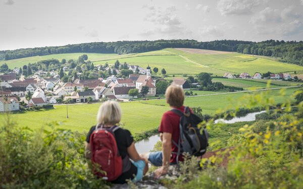
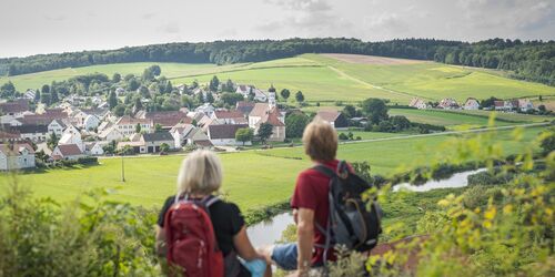
Are you and your e-bike fit and fully equipped? Then it's time to head back. Your route takes you along the "Panorama" cycle path.
Now you cycle west along the former railway embankment of the König-Ludwig railway along the idyllic Wörnitz until you reach Felsheim and finally Wörnitzstein.
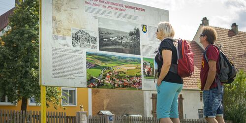
A meteorite hit this area 15 million years ago. The almost circular basin created by the so-called Ries event is today the best-preserved crater in Europe and one of the best-preserved large impact craters on earth. It has a diameter of 25 kilometres and a crater rim up to 150 metres high. The largely unwooded but densely populated basin of the Nördlinger Ries impact crater is clearly visible in the landscape.
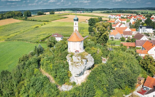
During the meteorite impact, chunks of rock were ejected from the earth and fell as colourful masses of rubble around the crater. The Kavalerienberg geotope is located in the middle of the geological debris field and is part of the Ries Geopark, one of only five UNESCO Geoparks in Germany. An almost two kilometre long nature trail leads through the geotope.
The trail also leads to the Sendenberg. From here, the views extend into the Danube valley with Donauwörth, the Schellenberg and the Holy Cross Monastery as well as into the Wörnitz valley, Ebermergen, the Rauhe Bürg and the Großer Hühnerberg.
Am Kalvarienberg
86609
Donauwörth

Take the bridge over the Wörnitz and cycle west and south across fields and forests towards Oppertshofen. You leave the Franconian Alb and cross the foothills of the Swabian Alb.
After a climb, you roll down into the Kesseltal valley. After Oppertshofen, the cycle path leads to Kesselostheim and northwards to Buggenhofen.
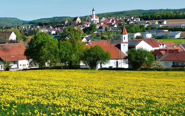
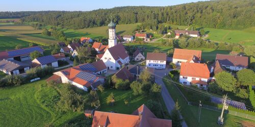
Here you have the opportunity to descend once to take a look at the pilgrimage church of the Assumption of the Virgin Mary, which is simple on the outside but very artistically decorated on the inside.
More than half a millennium ago, in 1471 to be precise, the inhabitants of Buggenhofen found a miraculous carved statue of the Virgin Mary together with an altar in the undergrowth. The construction of a pilgrimage church began in the same year.
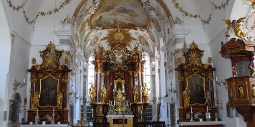
200 years later, the devastation and repeated looting during the Thirty Years' War forced the church to be rebuilt for the first time. At the beginning of the 18th century, the tower was rebuilt and on the 300th anniversary of the pilgrimage, the church was given a completely new interior in the Baroque and Rococo style, which has been preserved to this day.
The delicately coloured frescoes by Johann Baptist Enderle from 1769 are particularly impressive, as are the stuccowork by Laurentin Hieber and numerous figures and sculptural decorations by Johann Georg Bschorer.
The church is usually open daily from 8 am to 6 pm.
Buggenhofen 12
86657
Bissingen
You're probably too early, as Meinhard Steinle's pilgrimage restaurant doesn't open until the evening. (Buggenhofen 2, 86657 Bissingen, Tel. 09084 920 429) But locals recommend stopping off here and enjoying the finely selected and lovingly prepared food on the spacious terrace in summer.
The next stage takes you uphill past Rohrbach before you reach Untermagerbein an der Kessel.
Before you reach Fraunhofen, you will come to the perhaps somewhat spooky stage destination on the Michelsberg below the Frohnhofen castle stables - a ruined, high medieval hilltop castle.
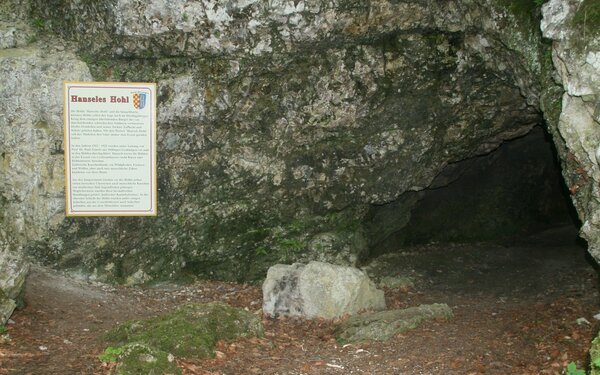
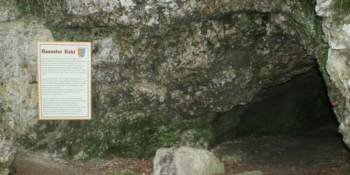
The small Hanseles Hohl cave is located halfway up the steep northern side of the Michelsberg. A hundred years ago, excavations uncovered rich Ice Age fauna, a Palaeolithic human tooth and evidence of a Neolithic settlement.
Over 7000 years ago, this area was home to the Linear Pottery, the oldest Neolithic farming culture that settled in permanent settlements. It is named after the characteristic band patterns of angular, spiral or wavy lines with which they decorated their ceramic vessels.
Whether and, if so, why these people might have eaten other people is still being debated by scientists today. At the beginning of the 20th century, archaeologists discovered charred human bones on a Neolithic hearth outside Hanseles Hohl cave. Did they find traces of cannibalism? Did sacrificial rituals take place here many thousands of years ago?
Ahead of you is a long climb that takes you to the highest point of the tour near Gaishardt.
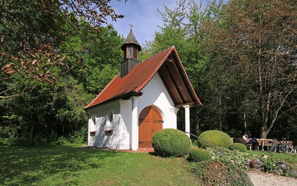
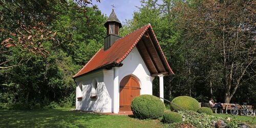
Now it's a steep downhill to Unterbissingen and back along the Kessel, this time on the south bank. Then via Brachstadt to the Maria Magdalena forest chapel near Erlingshofen, which has a unique history.
The Maria Magdalena forest chapel is not the result of a miracle or an apparition of a saint. It was created by thirteen footballers in a beer mood. When they celebrated Father's Day at the viewing point at the "Fuchsbau" as they do every year in 1989, one of them spontaneously had the idea of building a chapel. That same evening, pledges totalling 15,000 marks were collected. The project was forgotten by Morgan.
Three years later. The promissory note from that evening has resurfaced. Various chapels in the area were inspected and Mayor Alfred Stöckl gave his approval for a building on municipal land. The football fans build their forest chapel.
Today, the people of Erlingshofen and their guests find a Gothic-style building with four prayer benches on a hill on the edge of the Fronholz north of the village. The altar in the interior is lined with frescoes of the patron saint Mary Magdalene and St Francis of Assisi.
Frohnholzstraße
86660
Erlingshofen

Now it's back to the starting point in Donauwörth.
If you want to fortify yourself with some good Bavarian-Swabian cuisine, why not stop by the Goldener Hirsch in the centre of Donauwörth before you leave? (Reichsstraße 44, 86609 Donauwörth, Tel. 0906 3124) Here you can expect fresh and varied dishes from the region.
Start/Ende
Bhf DonauwörthBahnhofstr. 34
86609 Donauwörth