
Bahnhofstraße 12
91541 Rothenburg ob der Tauber

A bottomless pit, the best-preserved hilltop castle in Franconia and the source of the Altmühl - this cycle tour across the Franconian Heights offers you a varied programme along the route.
A cycle tour for nature lovers and connoisseurs
Arrive relaxed and hire bikes from the local hire companies. The capacity for taking bikes on the trains is limited and, depending on capacity utilisation, taking your own bike on board cannot be guaranteed.
Our tip: Please make sure to check your train connection and the expected capacity before you start your journey.
There are 48 bicycle parking spaces in the immediate vicinity of the railway station.
Bahnhofstraße 12
91541
Rothenburg ob der Tauber
From the railway station, walk south past the cemetery and take Erlbacher Straße to Bensenstraße, where the bike hire shop is located.
"Rad & Tat" Rothenburg rents out ladies' and men's e-bikes. Customers can also get advice on tours if required. The hire bikes are customised to the rider. Online bookings can be made on the website www.e-radtat.de, where you can also find pictures of the various bikes. The team can answer questions about prices and other details by telephone.
Bensenstr. 17
91541
Rothenburg
You first pass the Spitalbastei, the southern end of Rothenburg's historic town wall - a bulwark with several gates, portcullis and drawbridge.
The route continues along the Tauber towards Gebsattel. There you cross the river and follow a disused railway line.
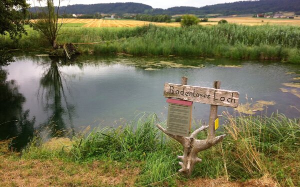
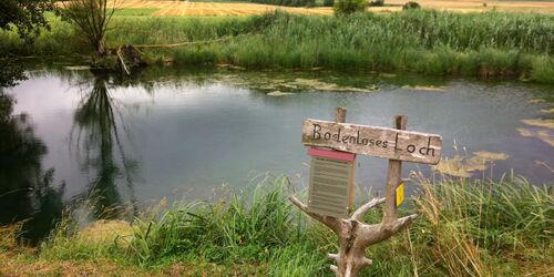
If you want to take a shortcut, continue past Diebach on the "Alte Bahnlinie" (AB) or "Fränkischer Wasserweg" (FW) cycle path to Unteroestheim, where you will find the "Bodenlose Loch" (bottomless pit) to the south-west of the village. However, the route via Insingen is worthwhile because of the pretty village centre.
The "bottomlessness" of this natural monument is not to be taken literally. It is a gypsum karst spring.
Every second, 60 to 80 litres of water flow out of a 6-metre-deep and 8-metre-wide gorge in the middle of the 15-metre-wide pond, the so-called hole. The water contains calcium sulphate, i.e. gypsum in dissolved form. The spring was created by karstification of a layer of gypsum in the ground. The water has to penetrate overlying layers of clay in order to reach the surface. It has found its outlet in the funnel-shaped hole. The blue to turquoise shimmering gorge is overgrown with numerous aquatic plants. The spring water flows into the Tauber via the Oestheimer Bach stream.
Auf der Heiligenwiese
91538
Diebach-Oestheim
There is also a cosy country inn in Unteroestheim where you can fortify yourself for your onward journey.
The "Schwarzer Adler" serves hearty country cuisine. The Wildermann family not only run the rustic inn and hotel guesthouse, but also their own farm. This means that mainly home-grown produce ends up on the menu. Guests can choose between Franconian specialities such as Schäufele and Sauerbraten as well as pork schnitzel or fish - all at moderate prices. Booking by telephone is recommended at weekends.
Würzburger Str. 8
91583
Diebach
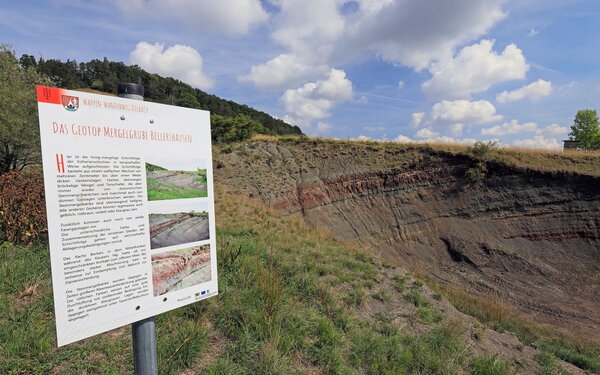
After Bellershausen, follow the cycle path "Radschmetterling Blauer Flügel" (RsB). In the immediate vicinity of the next village, another geological attraction awaits you: the Bellershausen marl pit. Behind the village, a dirt track leads to the geotope.
From the edge of the pit, you also have a wonderful view of the Frankenhöhe and Schillingsfürst Castle in the neighbouring village of the same name.
The artificial pit was once used to extract marl. Marl is an important raw material for cement production and was also used in agriculture in the past to make wet fields passable. The individual layers of rock can still be clearly recognised in the pit. The layers, which range from a few centimetres to over a metre thick, can be easily distinguished by their colour and structure. Crumbly marl and clay shale are predominant, interspersed with small banks of marlstone and isolated thin layers of gypsum. A board at the edge of the pit provides information about the formation and structure of the layers of earth.

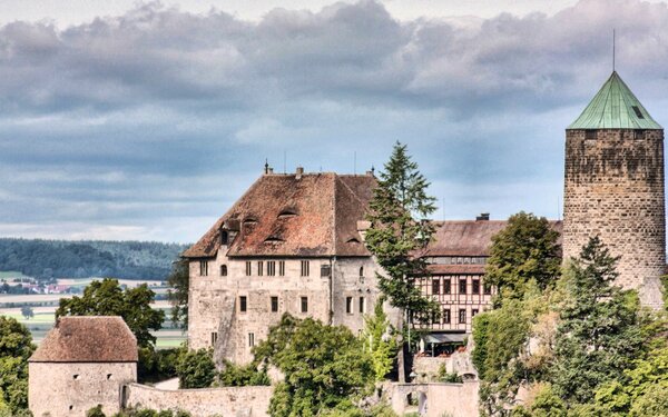
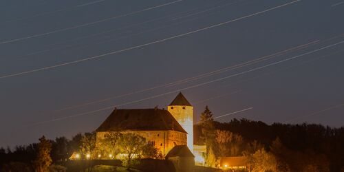
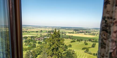
The route now runs through woods and fields to the south of the Frankenhöhe. Shortly before Schönbronn, you pass the idyllic Rothenburg-Schönbronn golf park. Shortly before Frommetsfelden, you reach the Altmühl valley. Flanked by the strongly meandering river, you now cycle into Colmberg. The castle, which towers high above the town, beckons from afar.
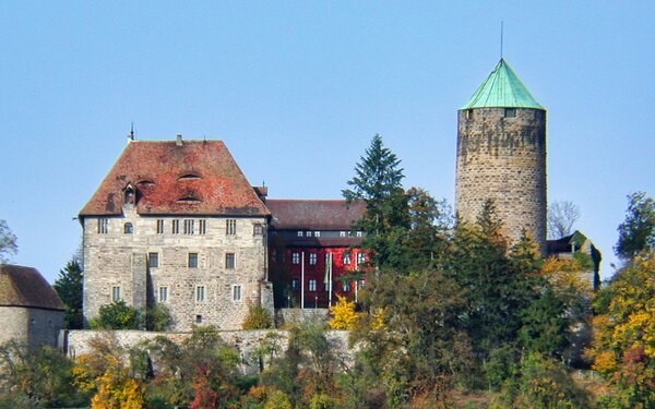
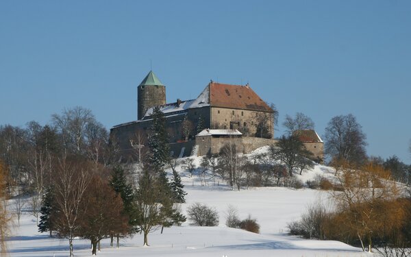
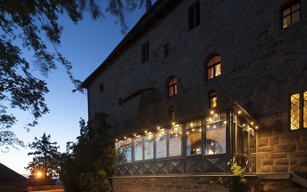
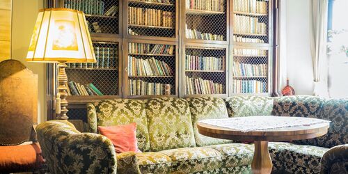
The medieval Colmberg Castle is located on a spur in the Altmühltal valley, 35 metres above Colmberg. It is considered one of the best-preserved hilltop castles in Franconia. The Hohenstaufen emperors developed Colmberg into an imperial castle. The lower part of the palace and the 35 metre high keep date back to the 12th and 13th centuries. After the end of the Hohenstaufen dynasty, a rather inglorious chapter began at Colmberg Castle. Poorly remunerated bailiffs wreaked havoc here. The fortress was outlawed as a castle of robber barons. In 1318, the Hohenzollerns acquired the castle, which remained in their possession for almost 500 years. Today, the historic walls house a hotel and a Franconian speciality restaurant with a fireplace room and conservatory, from where you have a magnificent view over the village of Colmberg and the Altmühl Valley.
An der Burgenstraße
91598
Colmberg


As you leave Colmberg, you will enjoy beautiful views of the western side of the castle.
The path now leads past small ponds, the wooded Eichberg and a 300-year-old oak tree that stands right on the edge of the path.
After Ober- and Unterhegenau, you reach Binzwangen. This is a district of Colmberg with half-timbered houses worth seeing.
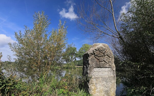
From there to Hornau, you cycle along the Altmühl again, which has its source in the area around Hornau.
The Altmühl is one of the slowest rivers in Germany and flows into the Danube. It also has 3 sources. Which one is the right one has been the subject of much debate. Two springs lie to the north of Hornau and flow into the Hornauer Weiher. A third spring emerges from the pond in the south. This was recognised as the official Altmühl spring in 1904 by the "Royal Bavarian Hydrotechnical Bureau in Munich". A large stone marks this spot today. There is also an inn at the pond, whose speciality is baked carp.
Hornau 37
91635
Windelsbach

The route also leads to the two other Altmühl springs, which are located just above Hornau in the village of Erlach and at the Hirschteich pond.
If you want to stop at one spring and shorten the route by around 7 kilometres, you can cycle via the idyllic village of Windelsbach, sometimes along a beautiful stretch of forest.
On the last stretch, you cycle relaxed down the Frankenhöhe back to Rothenburg.
From Hornau at the latest, you can follow the "Tauber-Altmühl-Radweg" (TA).
Start/Ende
Bhf. Rothenburg ob der TauberBahnhofstraße 12
91541 Rothenburg ob der Tauber